


This trip featured day-hikes at several National Monuments, rather than any serious backpacking. It was still a blast, though. Click the thumbnails to view the higer-resolution images.
Canyon de Chelly, Arizona
I posted a page with information and photos on Canyon de Chelly some years ago. This place remains a favorite of ours, and we never miss a chance to visit it if our route lies nearby.
|
White House ruin, from the rim of the main canyon. This ruin, like most of the larger ruins in the canyon system, was inhabited by the Anasazi peoples during the Great Pueblo era (c. AD 1100 to AD 1300). | |
Louise on the upper White House ruin trail; the trail drops 600 ft over the distance af about a mile to the canyon floor. | |
|
White House ruin; the buildings of the lower level originally extended up to the niche-level structures. | |
Tse Na'ashjiilii, or Spider Rock, so-named because it figures in the Navajo legends of Spider Woman, the yei (deity) who taught the Navajo people the craft of weaving. | |
|
Antelope House ruin from the rim of Canyon del Muerto, named for the Navajo pictographs painted nearby. | |
A Navajo home and farm in Canyon del Muerto. | |
|
The Mummy Cave, named for a mummified pair of bodies wrapped in coarse yucca-fiber netting found in a nearby burial cist. The ruin consists of structures in a pair of alcoves, joined by a tower on a connecting ledge. | |
Massacre Cave; Navajo oral tradition relates that over 100 women, children and elderly men were found and destroyed in this place by a punitive expedition led by Antonio Narbona in 1805. The cave is pocked with bullet marks and littered with bones. | |
|
A picturesque looking juniper at an overlook along Canyon del Muerto, 'cuz we like picturesque looking junipers. | |
Storage cists tucked into caves along the canyon rim; these were often used to store food. |
Navajo Bridge, Arizona
Along the way from Canyon de Chelly to the north rim of the Grand Canyon we crossed Navajo Bridge, over the Colorado River. The bridge was constructed 1927-1929. We'd been across it several times before it was replaced by the new bridge in 1995. The old bridge is still open to foot traffic, and there's a little museum/visitors' center on the site.
 |
Facing east across the Colorado River Gorge; the old span is on the left, the newer one on the right. |  |
Louise on old Navajo Bridge. | |
 |
North up the Colorado River from the center of the old Navajo Bridge. |
Grand Canyon at the North Rim, Arizona
The south rim of the Grand Canyon is generally more popular than the north, mostly because it's easier reach from the interstate highways, and is consequently more developed. Louise and I prefer north rim because it's (relatively) less crowded, and because there are wonderful places to camp in the nearby Kaibab National Forest. Our first camp was at Marble Point, overlooking Marble Canyon (part of the Grand Canyon system).
 |
When we arrived at Marble Point there was a lot of blowing rain and drifting mist, which provides its own sort of wild and pleasantly melancholy beauty. Here's a shot of Louise walking toward the canyon rim. |  |
The trees are leaning to the wind and the mists obscure the view; however... | |
 |
...the next day the weather had cleared up a bit, and we could see the canyon cliffs. |  |
A shot of me standing beneath another picturesque juniper at Marble Point. | |
 |
A view over the Grand Canyon from the lodge. | 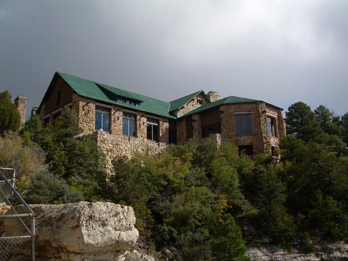 |
Grand Canyon Lodge at North Rim Village. | |
 |
Angel Window and viewpoint along the Cape Royal trail. |  |
View from Cape Royal. | |
 |
A viewpoint from a trail along the Cape Royal Drive, the name of which I can't recall at the moment. |
We also hiked a couple of miles down the North Kaibab Trail into the canyon. I don't recommend it unless you intend to go all the way into the canyon; the trail is heavily trafficed by mule-back tours, and the concentrated stench of mule urine is truly a thing to inspire awe.
Bryce Canyon, Utah
This is only the second trip we've made to this place together, although Louise has been here a time or two before me. My own taste for canyon hiking are the deep sandstone slot canyons you find all over southern Utah and northern Arizona. Still, Bryce Canyon has it's own undeniable charm. The erosional patterns have rendered the massive stone formations deceptively delicate to the eye, and this effect is enhanced by strata shaded in orange, pink and cream.
 |
This is a view from the Fairyland Loop Trail, an 8 mile round trip that can be started from the campground. |  |
Another view along the Fairyland Loop. | |
 |
Louise poses in front of the "Dragon Pine", as she has dubbed it, along the Fairyland Loop. |  |
Louise and me in front of Tower Bridge, Fairyland Loop. | |
 |
View from Queen's Garden/Navajo Loop trail. |  |
The formation known as "Queen Victoria"; contrary to my expectation, she seems to be amused after all. | |
 |
Louise among the manzanita bushes, along the Queen's Garden/Navajo Loop trail. |
Have I mentioned that all of these places we've been have a high elevation? Bryce Canyon is at 9,600'; be prepared for chilly evenings.
Escalante, Utah
This place is an old favorite, from the days before it became a national monument. I have, in fact, devoted 3 pages on this site to previous hikes we've done in this fantastic area: one, two and three! On this particular trip we stopped in to hike Fiftymile Creek (whoa - take a deep breath; the hike's only 8 miles), which we had not yet explored. We then stopped for a side trip up the Dry Fork Coyote Gulch.
 |
That's me in the upper part of 50-mile Canyon. |  |
Narrows in the upper part of 50-mile Canyon. | |
 |
Desert primrose found in bloom in 50-mile Canyon. |  |
An arch forming near the top of the canyon wall; come back and check it again in 4 or 5 thousand years, and see how it's grown. | |
 |
Nothing special - just a shot down 50-mile Canyon I happened to like. | 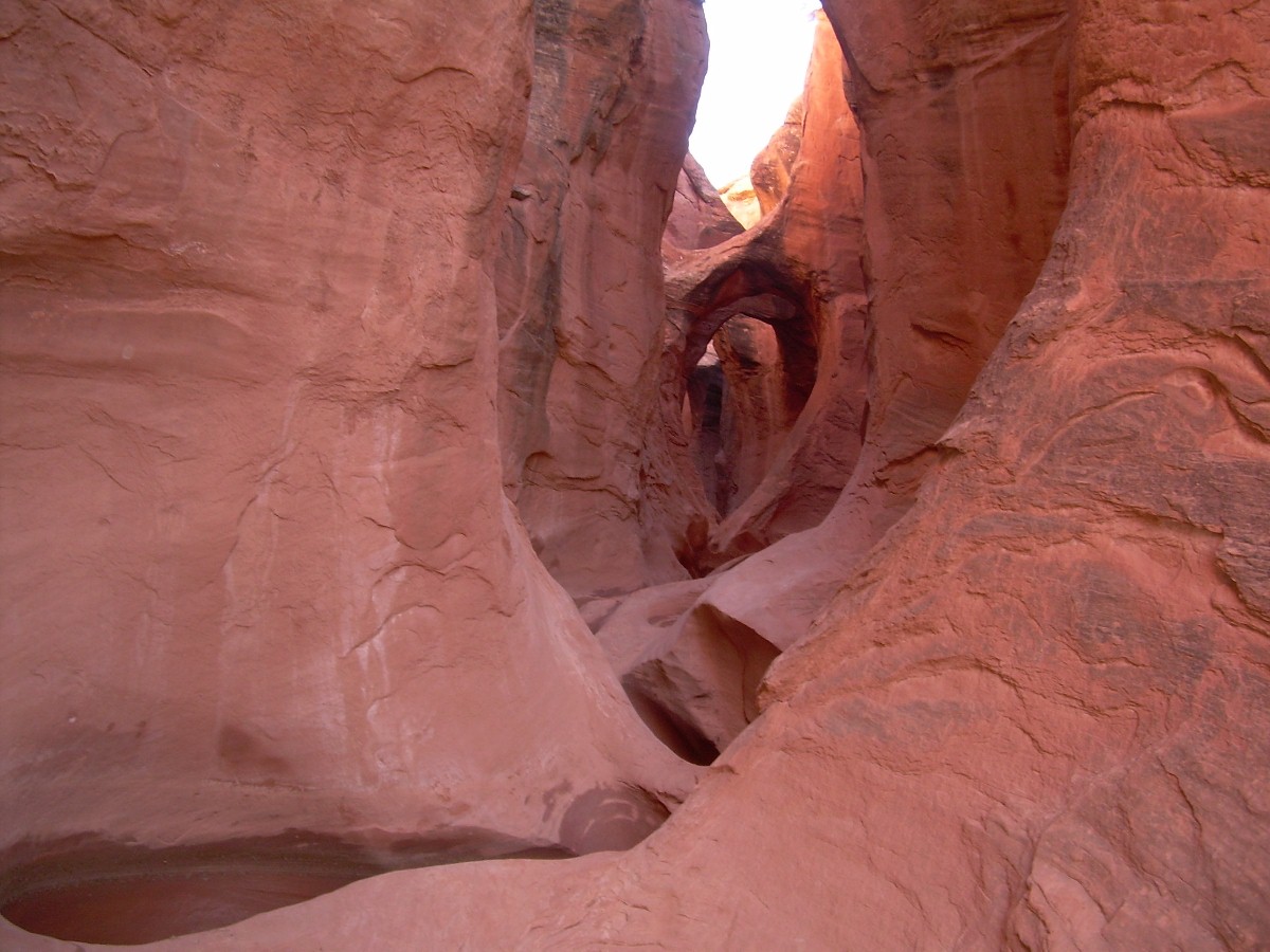 |
This is a shot down a small slot-canyon called Peekaboo Canyon, that can be found in the Coyote Gulch Dry Fork. |
Capitol Reef, Utah
We've been here pretty often, both from the main entrance along state route 24, and through the back door by way of Hall's Crossing and the Escalante. On this trip we came in the main entrance and stayed long enough to make one 12 mile hike along the Frying Pan Trail.
 |
Cohab Canyon Trail, leading to the Frying Pan Trail. |  |
Eroded rock in Cohab Canyon. | |
 |
Looking toward Cohab Canyon from the Frying Pan Trail. |  |
View along the Frying Pan Trail. Looks hot, dunnit? | |
 |
Cassidy Arch - yeah, it's named after Butch. Don't think there's any real connection, though. |
Natural Bridges, Utah
This is a perenial favorite, 'cuz it's on its way to just about everywhere we like to hike. The campground is nice and the 10 mile loop trail through White and Armstrong Canyons is worth the walk. Like Grand Gulch, the canyons were formed in the pale Cedar Mesa Sandstone formation. The bridges were formed by a combination of stream water and wind erosion (arches, by definition, are formed only by wind erosion).
 |
Sipapu Bridge, where you enter White Canyon for the loop trail hike. |  |
A ladder is provided for the last drop into White Canyon, near Sipapu Bridge. | |
 |
The Anasazi left their handprints in pigment on the canyon wall here. Archaeologists say it has a ritual significance, but it could've just been a cool thing to do one Saturday night. |  |
Another desert primrose - this one's yellow. | |
 |
A storage cist tucked into a wall downstream from Horsecollar ruin. |  |
A small arch up on the canyon wall. | |
 |
Kachina Bridge, near the confluence with Armstrong Canyon. There's a sizeable Anasazi ruin tucked in behind a boulder fall in this area. |  |
Petrograffiti left on Kachina Bridge. Ritual signifigance. Definitely. | |
 |
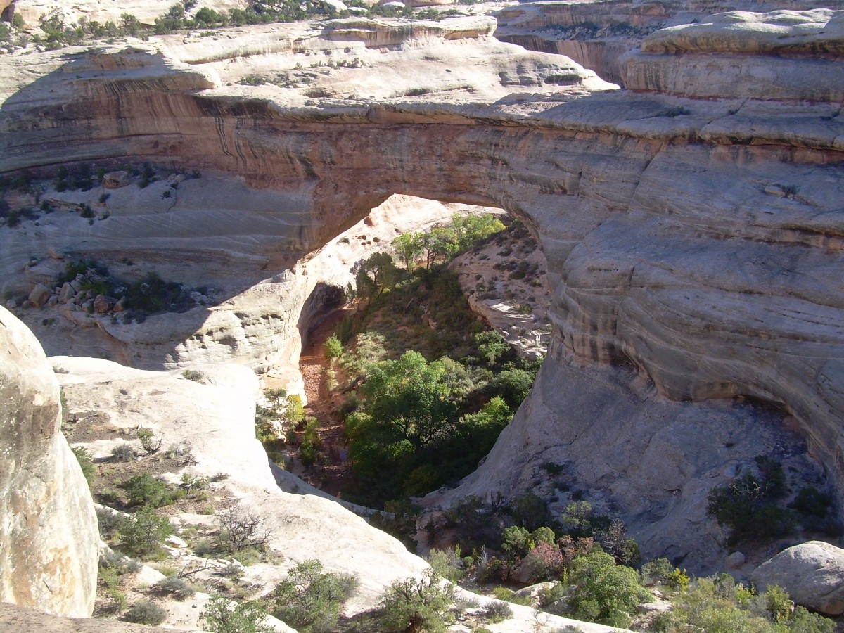
A large petroglyph panel can be found up Armstrong Canyon, a mile or so downstream of... |  |
...Owachomo Bridge. This is the last of the three featured bridges in the monument. At this point you climb out of Armstrong Canyon to the rim. |
After leaving Armstrong Canyon, it's about a 3 mile hike over sandy trails and slickrock, back to the Sipapu Bridge overlook.
