


|
Sand and slickrock alternate underfoot for the first two miles of the trail, to the rim of the canyon. This part of the trail makes for an easy and beautiful day-hike. |
|---|---|
|
Two miles from the trailhead is the rim of the canyon, with views up and down the Dark Canyon gorge. The next mile descends a precarious cairned-trail down a 50° talus slope, for a total elevation change of roughly 1,120 feet. |
|
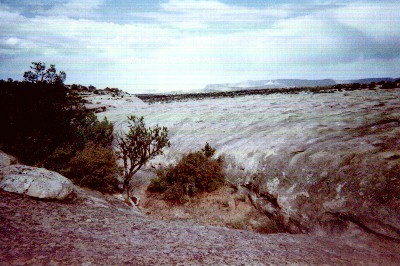
The trail on the talus slope is almost always in direct sunlight. We were fortunate in having overcast skies, and even some occasional light drizzle, to keep us cool on the way down. By afternoon the clouds had cleared, and the trip back up the slope was very hot. This is a shot of drifting mist advancing down Dark Canyon, from roughly halfway down the talus slope. Click on the image for an expanded view. |
|
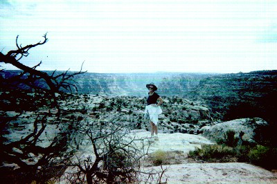
The trail down the talus slope ends in a small draw that leads down to the main canyon. This is a view back up the talus slope from the draw; Louise's tiny figure (green circle) will give you some idea of the scale involved. Click on the image for an expanded view. |
|
This is a view down the main canyon, which starts about a quarter to half a mile down the draw. On the way down we missed the easy trail above the draw on the right side, and consequently did more boulder-scrambling than was necessary. The main canyon always has water, but there is none to be had along the trail until you reach this point. Louise and I carried a gallon with us from the trailhead, and used almost all of it by the time we returned to our vehicle. Click on the image for an expanded view. |
The most popular trail guide to Dark Canyon is a slender volume with gray card-stock covers published by the Canyonlands Natural History Association. This is available at most of the visitor's centers in the area, from Canyonlands to Natural Bridges. Some of the directions are out of date, however, as many of the county road designations have changed. Here are the directions as we encountered them in 2001:
If you are approaching the trail from the east along Utah Highway 95, travel about 36.5 miles past the Natural Bridges National Monument access road, then turn right on County Road 2731 (if you see mile-post 53 on U-95, you missed the turn). This is an unmarked turn onto a graded dirt road, but you should see the county road sign shortly after you pass over the cattle-guard. Keep to the main road for 5.1 miles; the route merges into CR2081, which comes in from the left. Turn right down CR2081. Stay on this road for about 4.2 miles (you'll pass CR2641 at about 3 miles), and turn left on CR256. From here, it is about 2.4 miles to the trailhead.
